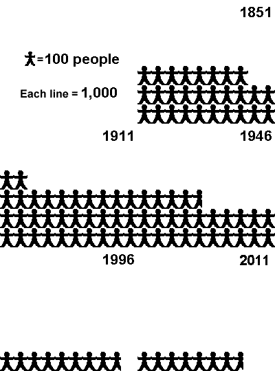
| Gweedore and the Rosses | ||||||||||||
| Area | Totals | 2,824 | 2,805 | 2,636 | 3,202 | 2,468 | 1,444 | 987 | 880 | 765 | 813 | 769 |
| Sq. Km | Island / Year | 1841 | 1851 | 1891 | 1911 | 1946 | 1966 | 1986 | 1996 | 2002 | 2006 | 2011 |
| 18.34 | Arranmore | 1,415 | 1,160 | 1,103 | 1,533 | 1,344 | 847 | 735 | 602 | 543 | 522 | 514 |
| 3.54 | Tory | 399 | 402 | 348 | 307 | 265 | 243 | 136 | 169 | 133 | 142 | 144 |
| 3.11 | Cruit | 258 | 252 | 252 | 255 | 172 | 86 | 89 | 70 | 61 | 53 | 85 |
| 1.39 | Inishfree Upper | 137 | 216 | 182 | 206 | 96 | 47 | 17 | 15 | 7 | 9 | 2 |
| 1.18 | Inishbofin | 121 | 122 | 146 | 166 | 139 | 98 | 6 | 24 | 16 | 36 | 11 |
| 1.19 | Rutland | 125 | 108 | 87 | 78 | 50 | 2 | 4 | 0 | 0 | 13 | 1 |
| 1.29 | Owey | 94 | 118 | 139 | 152 | 105 | 76 | 0 | 0 | 0 | 27 | 0 |
| 1.79 | Gola | 68 | 143 | 131 | 169 | 132 | 43 | 0 | 0 | 5 | 4 | 15 |
| 0.52 | Inishmeane | 12 | 57 | 68 | 82 | 62 | 2 | 0 | 0 | 0 | 0 | 7 |
| 0.19 | Inishkeeragh | 52 | 66 | 60 | 117 | 64 | 0 | 0 | 0 | 0 | 7 | 0 |
| 0.20 | Eighter | 59 | 57 | 35 | 40 | 15 | 0 | 0 | 0 | 0 | 0 | 0 |
| 0.47 | Inishirrer | 0 | 26 | 28 | 41 | 18 | 0 | 0 | 0 | 0 | 0 | 0 |
| 0.42 | Inishcoo | 37 | 18 | 18 | 9 | 6 | 0 | 0 | 0 | 0 | 0 | 0 |
| 0.30 | Inishal | 43 | 60 | 35 | 36 | 0 | 0 | 0 | 0 | 0 | 0 | 0 |
| 0.23 | Inishinny | 4 | 0 | 4 | 11 | 0 | 0 | 0 | 0 | 0 | 0 | 0 |
