
Inishtrahull lies about 12.5 km north-east of Malin Head.
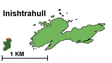
The Tor Rocks which lie about 2 km further north-north-west comprise six rocky pinnacles rising to 20m above the levelnd are the most northerly point of land in Ireland, . The island of Inishtrahull (34 ha) rises to 43 m at its western end and extends west-east for some 1.5 km. The rock is Lewisian gneiss, the oldest rock in Ireland, and this rock similar to rock found in southern Greenland and some of the Hebridean Islands.
Source: NPWS website
The Tor Rocks which lie about 2 km further north-north-west comprise six rocky pinnacles rising to 20m above the levelnd are the most northerly point of land in Ireland, . The island of Inishtrahull (34 ha) rises to 43 m at its western end and extends west-east for some 1.5 km. The rock is Lewisian gneiss, the oldest rock in Ireland, and this rock similar to rock found in southern Greenland and some of the Hebridean Islands.
Eider Ducks
In 1912 Inishtrahull became the first recorded Irish breeding site for Eider sea ducks (over 200 pairs in 1991/92),Source: NPWS website

Inishtrahull - Inish Trá Thall (possibly Island of the distant shore)
The Book of Inishtrahull - Seán Beattie
Foyle Press - 1992, Reprinted 1997
NPWS